36.2 What "depth" means, and where it comes from⧉
The previous chapter showed what a second viewpoint buys you, depth through disparity, and derived the two-view algebra that makes it precise. Before we spend the rest of the part recovering depth from one image, from many images, and from casual photo sets, pin down a question that sounds trivial and is not: what, exactly, is "depth," and where does it come from? Getting the definition wrong is the single most common way to write buggy 3-D code, and the inventory of sources is the map for everything that follows.
36.2.1 Depth means the camera-frame z-coordinate⧉
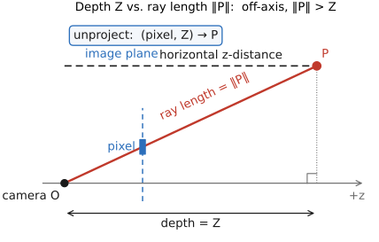
In this book depth means the $z$-coordinate of a scene point in the camera's frame, its signed distance along the optical axis, measured on the plane parallel to the image sensor. The range, the Euclidean length of the ray from the camera center to the point, is a different quantity. The two agree only for a point dead ahead on the axis; for a point off to the side, the ray is longer than its $z$ (by a factor of $1/\cos\theta$, where $\theta$ is the angle off-axis). A flat wall photographed head-on has constant depth across the whole image but increasing range toward the edges; confuse the two and your reconstructed wall bows toward the camera at the corners.
The reason to standardize on $z$ is that it is exactly the quantity perspective projection threw away. Recall from Chapter 2.2, Pinhole Image Formation and linear perspective that projection maps a 3-D point $(X, Y, Z)$ to image coordinates $x = fX/Z$, $y = fY/Z$. It divides by $Z$ and then forgets $Z$. Unprojection is the inverse operation: given a pixel $(x, y)$ and its depth $Z$, recover the 3-D point $X = xZ/f$, $Y = yZ/f$. Depth is precisely the one missing number per pixel that turns the irreversible projection back into an invertible map. That is why a depth map already is a 3-D reconstruction: pixel grid plus per-pixel $z$ unprojects to a full 3-D point field.
Two data structures recur throughout the part, and they are the same object at different levels of processing. A depth map is just a per-pixel $z$ image, one scalar per pixel, the same resolution as the photo, often visualized as brightness (near = bright) or a colormap. A point map, the term DUSt3R popularizes later in this part, is its unprojected form: a per-pixel 3-D point $(X, Y, Z)$ in some chosen coordinate frame, i.e. the depth map already pushed out into space through the camera intrinsics. A depth map needs the camera's calibration to become 3-D; a point map has that step already baked in. Both are image-shaped: a depth map stores one scalar per pixel, while a point map stores a 3-D vector, which is exactly why they are so convenient for neural networks to regress.
36.2.2 Where depth comes from: a cue-and-sensor inventory⧉
Depth can be computed from images or measured by hardware, and the methods divide along that line. Each entry below has a proper home (some earlier in the book, some in the chapters ahead), but collecting them on one page makes the contrasts visible. The active sensors (the lower half of the list) are deliberately only pointed to here: this part is about computing depth and shape from images, not about depth-sensing hardware, which lives with the sensors and optics material.
- Stereo / disparity: two views; triangulate matched points from a known baseline and the correspondence shift. The depth-from-two-views story of Chapter 36.1, Multiple view geometry: $Z = fB/d$.
- Multi-view: many views; the structure-from-motion + multi-view-stereo pipeline (later in this part) chains pairwise geometry across dozens of images into a globally consistent reconstruction.
- Defocus / focus: a point off the focus plane blurs by an amount that grows with its distance from that plane, so the size of the blur encodes depth (depth-from-defocus); a focal stack sweeps focus and reads depth from where each pixel is sharpest. → Part 31, Light fields and plenoptic cameras and Part 32, Multi-aperture imaging (depth-from-defocus via Chapter 33.3, Coded aperture), and the depth-of-field material of Chapter 23.2, Fake (synthetic) depth of field.
- Dual-pixel: the half-aperture parallax that phone sensors already capture for autofocus is a tiny stereo pair the width of one lens; phones reuse it for portrait-mode depth. → Optics (dual-pixel AF).
- Motion: a moving camera turns time into baseline: structure-from-motion and optical-flow parallax recover depth from how the scene streams past. → Matching pixels across space and time.
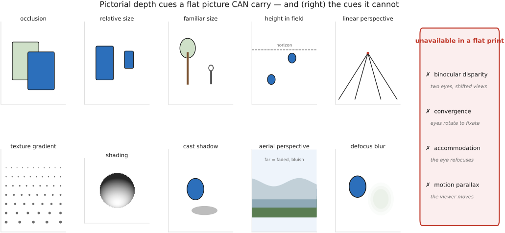
- Monocular cues: a single still already reads as three-dimensional to a human, through occlusion and T-junctions, linear perspective and vanishing points, texture gradients, relative and familiar size, aerial perspective (haze), shading, and focus blur. Turning those cues into numbers is Chapter 36.3, Monocular depth estimation (one image → depth).
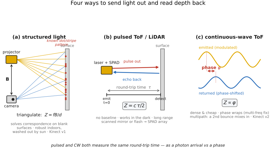
- Active depth: send light out and read it back: time-of-flight and LiDAR clock a pulse's or a modulated wave's round trip; structured light projects a known pattern and triangulates (Chapter 36.6, Structured light scanning below). Triangulation can return axial depth; time-of-flight initially gives range along the viewing ray, which must be converted to $z$. → depth sensors / optics (RealSense, phone face-ID dot projectors, Kinect).
36.2.3 Relative vs metric: the scale you usually don't have⧉
One catch runs through nearly every method above. A calibrated rigid multi-view reconstruction without a known metric baseline recovers geometry, in a nondegenerate case, only up to a similarity transform: an unknown overall scale, plus a rigid rotation and translation. The shape is right and the relative depths are right (this is nearer than that, by this ratio), but the absolute size of the world is unknown. Two views of a dollhouse and two views of a real house can produce identical reconstructions; nothing in the images themselves says which is which. This is relative (or "up-to-scale") depth.
To get metric depth, in real meters, something must fix the missing scale: a known baseline between two cameras, a calibration target of known size placed in the scene, or a metric sensor (LiDAR, time-of-flight) that measures distance in physical units directly. A single image is more ambiguous still: unconstrained geometry is not determined even up to one affine transformation. Some monocular estimators choose scale-and-shift-invariant depth or inverse depth as their training target; others use metric supervision. Keep the words straight: relative may mean ordering, scale-only depth, or an affine depth/disparity estimate; these preserve different quantities, while metric depth gives distances in physical units. State the convention before combining outputs or evaluating errors.